- BIST10012,151-0.94%
- USD49.220.00%
- EUR55.21+0.28%
- GOLD4,194.50-0.52%
- INTEREST37.00%-1.00
- BITCOIN82,961-0.85%
- October 13, 202619°
- BIST10012,151-0.94%
- USD49.220.00%
- EUR55.21+0.28%
- GOLD4,194.50-0.52%
- INTEREST37.00%-1.00
- BITCOIN82,961-0.85%
- October 13, 202619°
UN says 942 checkpoints in the West Bank restrict Palestinians' movement
The network in the occupied West Bank, consisting of 824 fixed checkpoints and closure points and 118 linear barriers, has reached a total length of 107.7 kilometers. Thirteen new fixed checkpoints and gates were added over the past two months, 10 of them in Jenin governorate.


The network of checkpoints, gates and barriers in the occupied West Bank has reached 942 points. It restricts Palestinians' movement between cities, towns and villages, separating communities from one another and from agricultural land.
The network includes 824 fixed checkpoints and closure points, along with 118 linear barriers, including earth mounds, trenches and roadblocks. The barriers have a combined length of 107.7 kilometers.
Hebron has the most checkpoints
Hebron governorate has the highest concentration of fixed checkpoints and closure points, with 221. There are 160 points in Ramallah and al-Bireh governorate, 120 in Nablus, 78 in Bethlehem, 62 in Jerusalem, 41 in Qalqilya and 40 in Salfit.
There are 27 checkpoints and closure points in Jericho and the Jordan Valley, 26 each in Jenin and Tulkarm, and 23 in Tubas. Thirteen new fixed checkpoints and gates were added over the past two months, while the number of fixed closure points in Jenin rose from 16 to 26.
In Jenin, new points were established in areas including al-Jalama, Arrana, the industrial zone, Deir Abu Daif, the entrance to Jenin city, Qabatiya, Umm al-Tut, the area around the Arab American University and the Zababdeh junction. New gates were also installed on the al-Jariyut road west of Ramallah and on rural roads in the governorate's western and northwestern areas.
The barrier network separates villages and agricultural land
The restrictions are not limited to fixed checkpoints. Iron gates blocking the entrances to towns and villages and agricultural roads, along with earth mounds, trenches and roadblocks, also cut across main and secondary routes.
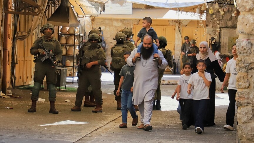
This network controls Palestinians' travel between cities, towns, workplaces, agricultural land and service centers. The closure of a single gate can force residents onto much longer alternative routes or separate villages and surrounding areas from one another for hours or days.
As checkpoints and gates have expanded, travel within the West Bank has been divided among separate routes and areas. Travel between neighboring communities has become dependent on the opening and closing of specific gates and checkpoints.
The Commission for Colonization and Wall Resistance documented the installation of gates by Israeli settlers on Palestinian roads and land. It identified gates in Wadi Hamad, belonging to Kafr Ni'ma, and east of Umm Safa, on a road leading to the home of a Palestinian family.
The number of barriers has risen in recent years
There were approximately 757 barriers across the West Bank in 2003. The number rose to 630 in 2008, 705 in 2018 and 793 in March 2024.
Data from the Office for the Coordination of Humanitarian Affairs showed that the number of barriers rose to 925 in December 2025 and to 942 in the latest figures. The 2025 data included 89 checkpoints operating around the clock, 218 partially operating checkpoints, 232 road gates, 114 linear closures, 167 earth mounds and 105 roadblocks.
The data indicate a shift from temporary earth barriers toward more permanent gates and checkpoints. The expansion of the network affects access to agricultural land and livelihoods, as well as students' access to schools, patients' access to hospitals and workers' access to workplaces.
As checkpoints and gates increasingly intersect with the West Bank's road network, travel distances between nearby communities are growing. Interconnected checkpoints, gates and closure points can turn a direct route into a longer road that passes through multiple checkpoints.
Stay Updated with The Turkiye Times
Subscribe to be informed about special news, developments and announcements. We will keep you informed.
By signing up, you agree to our Privacy Policy